Each Augmented Building originates from a polygonal footprint extracted from GIS data. This footprint is enriched with an attribute table containing key information necessary for procedural generation, geometric augmentation, and texture mapping.
2. Architectural Typology- Definition: The typology attribute categorizes architectural styles by region.
- Usage: Typology influences building height, structure, façade details, and roof shape.
- Global Classification:
- The planet is divided into 8 general architectural zones.
- Further subdivided into 68 specific typologies, ensuring region-specific accuracy.
- Classification is based on 20 years of architectural expertise and is optimized for ArcGIS CityEngine.
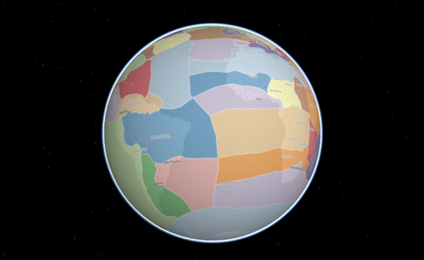
📌 Figure 1: Global vernacular architecture typology map.
3. Environmental Context
Buildings are influenced by environmental parameters to ensure realistic integration with their surroundings.
- Biome-Based Adjustments
- Definition: The biome classification segments the world into 14 climatic regions, based on temperature, precipitation, and ecosystem variations.
- Usage in Building Design:
- Determines roof inclination, overhangs, and material selection.
- Influences building adaptation to climate conditions (e.g., insulation in cold climates, reflective materials in deserts).
- Adjustments to architectural details based on altitude and environmental exposure.
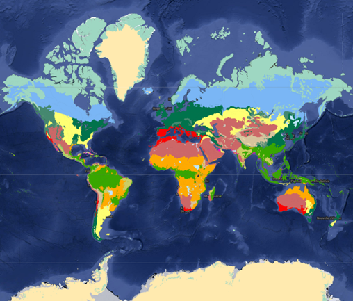
📌 Figure 2: Global biome segmentation.
4. Coastal Proximity Influence
- A specialized analysis assesses proximity to the coastline.
- Impact on building geometry:
- Unique façade treatments for coastal architecture.
- Adjustments to structural integrity to handle marine climate conditions.
5. Land Use & Land Cover (LULC) Influence
- Definition: LULC data categorizes the land where a building is constructed.
- Usage in Building Design:
- Classification into residential, commercial, or industrial categories.
- Procedural texture and geometry adjustments based on function.
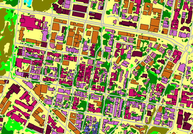
📌 Figure 3: Examples of LULC variations in procedural building design.
6. Procedural Generation & Geometric Augmentation
Once semantic data is assigned, procedural algorithms generate 3D geometry, ensuring realistic shapes and urban coherence.
Height Estimation & 3D Reconstruction- Methods of Height Determination:
- Shadow Analysis: Height estimated from shadow length on single-source images.
- Stereoscopic Analysis: Measured from multi-angle imagery for accuracy.
- Digital Height Models (DHM): Extracted from Digital Terrain Models (DTM) and Digital Surface Models (DSM).
 📌 Figure 4: DHM-based height extraction example.
Roof Geometry & Structural Enhancement
- Roof Type Detection:
- AI-driven detection of roofline structures identifies whether a roof is flat, gabled, or hipped.
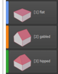
📌 Figure 5: Roof classification system.
- Procedural Enhancements:
- Overhangs, chimneys, HVAC units, and solar panels are added dynamically.

📌 Figure 6: Detected roof with ridges line

📌 Figure 7: Detected roof types
7. Façade & Ground-Level Detailing
- LOD3-Level Façade Augmentation:
- Procedural reconstruction of balconies, window structures, and urban elements.
- Ground-Level Modifications:
- Texturing differentiation for storefronts, residential entrances, and industrial façades.

📌 Figure 8: Example of Special Ground Floor Handling
8. Texturing & Material Application
Augmented Buildings integrate region-specific material libraries to enhance realism.
- Roof Color Extraction:
- Roof colors are derived from orthophoto sources, using dominant color analysis.
- Texture Mapping by Vernacular Region:
- Unique texture sets applied to façades and structural components.
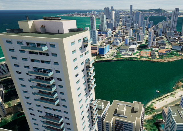
📌 Figure 9: Procedural generation example – Cartagena, Colombia.
 📌 Figure 10: Procedural generation example – Taipei, Taiwan.

📌 Figure 11: Procedural generation example – Rabat, Morocco.
9. Output Formats & Applications
Augmented Buildings are produced in OGC 3D Tiles format, ensuring compatibility with GIS and simulation platforms.
View the Compatibility of 3D Tiles Produced by BrightEarth
📌 Future planned formats:
- OpenUSD
10. Primary Applications
- Urban Planning & Digital Twins
- Smart City Simulations
- 3D GIS Mapping
- Game Engine & VR Integration
The Augmented Building design process combines AI-driven feature extraction, procedural geometry, and semantic attributes to transform raw 2D GIS data into fully enhanced 3D urban models. This highly scalable approach enables mass generation of cities and realistic urban landscapes with geotypical accuracy.
By integrating architectural typology, environmental adaptation, and procedural augmentation, Augmented Buildings set a new standard in 3D urban modeling, bridging the gap between geospatial data and interactive 3D environments.
Glossary
- LOD (Level of Detail): Open Geospatial Consortium (OGC) standard for urban model detail levels. LOD3 includes detailed façades, balconies, and windows.
- AGL (Above Ground Level): Height of a building relative to the ground surface.
- DHM (Digital Height Model): Elevation model including buildings and vegetation.
- LULC (Land Use / Land Cover): Classification of land type (e.g., urban, commercial, industrial).
- ArcGIS CityEngine: ESRI’s procedural city generation engine for GIS-based 3D urban modeling.